
Avalanche Bulletin
更新日時: 2022/11/30 07:00
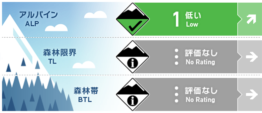
Tateyama
Alpine Fair Watch for increased snowfall and wind effects in the future.
Treeline
Below Treeline
信頼度:○ good □ Fair △ Low
Travel and Terrain Advice
At higher elevations, new wind slabs may have formed on extremely steep slopes just below ridgelines and branch ridges. Many "terrain traps" such as rocks and gullies are exposed that can cause extensive damage in the event of a small avalanche or slide. The Japan Meteorological Agency is forecasting a wintry pattern in the coming days. Temperatures are expected to drop and new snowfall and winds are expected to increase. Please pay attention to the changing weather conditions. Today marks the end of the fall avalanche bulletin for Tateyama. We would like to thank everyone who provided us with this information.
Avalanche Problem
ウインドスラブ Wind slab


Beware of extremely steep slopes just below the ridge and branch ridges.
概要
Avalanche
昨日(29日)、新しい雪崩の報告はないが入山者が少なかったため限定的な観察。
Snowpack
The snow surface is wet due to rainfall and elevated temperatures since yesterday afternoon. The snow may have been accompanied by strong winds at higher elevations. As a result, new wind slabs may have formed on the ridge and just below the branch ridges.
Weather
As of 6:00, the temperature in Murodo was 1.3°C and it was raining. The Japan Meteorological Agency is forecasting rain and occasionally cloudy skies in Toyama Prefecture, with some snow in the mountains in the late evening, as a winter pressure pattern is expected to gradually develop.