Avalanche Bulletin
更新日時: 2022/12/22 07:00
Niseko Yotei Yoichi Shiribeshi
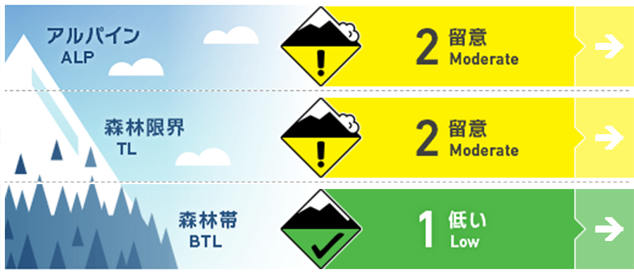
Alpine Fair Isolated pockets of wind slab may still exist around specific terrain features in the east.
Treeline Good The snow pack continues to settle and gain strength with little in the way of recent drifitng or new snow accumulation.
Below Treeline Good Little in the way of concern outside of specific terrain traps has been observed.
信頼度:○ good □ Fair △ Low

Travel and Terrain Advice
An early-season mindset continues to be needed when evaluating the terrain, in areas of thinner cover hazards just beneath the snow surface are of concern alongside weak snow bridges over rivers and streams. At higher elevations look for signs of wind slabs around ridgeline and be wary of rapildy changing surface condtions if we do get significant rain across the area.
Avalanche Problem
ウインドスラブ Wind slab


With reduced observations in the Alpine at present, we believe there remains the possibility of small pockets of wind slab on lee slopes. These slabs are likely to be found around ridgelines or cross-loaded depressions. Look for signs of smooth wind-pressed snow on the surface across easterly slopes.
概要
Avalanche
Although we have limited observation from the alpine no new natural or human-triggered avalanches have been reported.
Snowpack
After a period of continuous snowfall, a break in the storm cycle has brought little to no new snow over the last 24 hours. The pack continues to gain strength with no notable weak layers. The previously reported buried 70 to 100cm rain crust below 500m contines to become buried and of little concern at present.
Weather
A low-pressure system traveling up the east coast will split as it reaches Hokkaido bringing ever-changing wind directions and warmer temperatures throughout Thursday and into Friday. Winds speeds will remain low to moderate and we will receive intermittent snowfaw with the possibilty of periods of rain below 500m.


