
Avalanche Bulletin
更新日時: 2022/12/31 07:00
Niseko Yotei Yoichi Shiribeshi
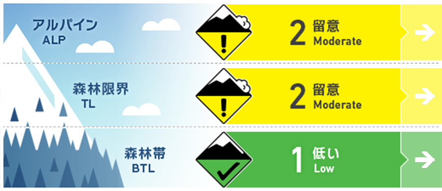
Alpine Fair Windslab has formed on features lee to the WNW winds
Treeline Good Windslab has formed on features lee to the WNW winds
Below Treeline Good Use normal caution.
信頼度:○ good □ Fair △ Low
Travel and Terrain Advice
Favorable weather today will permit access to the alpine and more challenging terrain. Look for windslab at higher elevations and evaluate conditions carefully before stepping onto steep slopes. The avalanche hazard will increase as the next storm arrives sunday afternoon with strong winds and heavy snow. Travel with extra caution on after the storm arrives. The next JAN bulletin will be released Tueaday Jan. 3.
Avalanche Problem
ウインドスラブ Wind slab


Look for windslab formation just below ridge crest and on protected features lee to the WNW winds
概要
Avalanche
A full depth explosive triggered avalanche released on the Mizuno-no-sawa West ridge. Glide cracks are forming on many slopes in the region. Reports of size 1-2 windslab activity on Shiribetsu on Dec. 29th.
Snowpack
The region has received steady snowfall for the past 48 hours with accumulations varying from 30-60cms. The East side of the forecast region (Shiribetsu) has received the heaviest snowfalls with less falling the Niseko and Yoichi areas. This new snow overlies a Melt freeze crust and a well settled base.
Weather
The previous storm has passed with winds easing off today and a chance of the occasional sunny break. The Westerly flow continues with the next storm cycle arriving Sunday afternoon with moderate to heavy snow expected to start Sunday night continuing through to Tuesday. Temperatures will remain cool through this period with the WNW picking up in intensity as the new storm arrives.


