
Avalanche Bulletin
更新日時: 2023/01/01 07:00
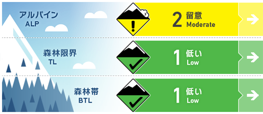
Myoko
Alpine Low Based on limited information
Treeline Low Based on limited information
Below Treeline Fair
信頼度:○ good □ Fair △ Low
Travel and Terrain Advice
Please note the very steep slopes that open to the south in the forest. Also, the snowpack is still very light, making fun runs below the treeline difficult. In addition, the gully is not yet filled and there are numerous holes and openings. Since it is still early in the season, it is a good idea to ski in ski resorts that are in good condition. The weather is clearly worsening. Heavy snow is in the forecast, so plan your activities accordingly. Wishing you all a very Happy New Year!
Avalanche Problem
ウインドスラブ Wind slab


ストームスラブ Storm slab


概要
Avalanche
Yesterday, a snow block collapse was observed on a very low elevation, south-facing extreme terrain.
Snowpack
At higher elevations, wind slabs form on the leeward side due to the influence of strong westerly winds. Wind effects are widespread. In addition, yesterday's fine weather and rising temperatures have caused the snow below treeline to settle and the snow surface to become wet. The snow depth is about 140 cm at an elevation of around 1,500 m. The lower part of snowpack at this elevation contains Melt-Freeze crusts formed by previous rainfall, but no significant instability has been observed.
Weather
The Japan Meteorological Agency is forecasting westerly winds, later, slightly stronger, rain or snow, morning to early afternoon, cloudy, with a high of 9°C (13 m elevation) for the Joetsu region of Niigata Prefecture. At Sasagamine, Myoko (elevation 1,310 m), the temperature is -3°C (as of 6 am), with no new snowfall. The weather is expected to worsen due to a pressure trough, and stormy weather is forecast for the night.