
Avalanche Bulletin
更新日時: 2023/01/05 07:00
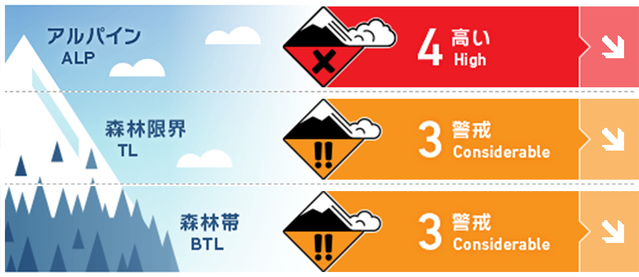
Niseko Yotei Yoichi Shiribeshi
Alpine Low Strong ridge top winds with heavy precipitation keep forming new wind slabs especially in the alpine.
Treeline Good Tree line has features that wind slabs have formed on.
Below Treeline Good Deep new snow takes time to settle.
信頼度:○ good □ Fair △ Low
Travel and Terrain Advice
A stepping back mindset with more conservative terrain choices is recommended. Don't ski alone, have a good pre trip plan with safer options. Know where you are in the terrain. With poor visibility avalanches from above could surprise you. Loose snow avalanches in steep terrain can sweep you into a gully or creek. Cornices have continued to build on ridges and can break back further than one may think. With deep unconsolidated new storm snow in sheltered areas it is easy to loose a ski or even get back up if one falls. Back off chosen terrain if you encounter stiff wind slabs with stronger snow over weaker. Good riding with less risk can be found in the trees on lower angled slopes.
Avalanche Problem
ウインドスラブ Wind slab


Strong winds and extreme gusts have continued to scour wind exposed ridges create stiff wind slabs lee and cross loaded features.
ストームスラブ Storm slab


Warmer temperatures this morning and continued snow will keep Storm slabs avalanches likely. New snow decrease on Friday and storms slabs avalanches will become less likely but remain possible.
概要
Avalanche
Pockets of skier triggered size 1 wind slab avalanches are still being reported. New wind slabs are still being created especially lee of ridge lines and cross loaded features. With moderate to heavy amounts of snow continuing to fall with warmer temperatures storm slabs tree line and below tree line are still a problem and need more time to bond.
Snowpack
1.5 meters of snow have fallen in many locations since the new year. the 12/29 melt freeze crust below 700m is still a layer of concern. Snow surface is highly variable depending on elevation and aspect. Crusty surfaces can be found on wind exposed ridges and deep stiff wind deposits on lee aspects in the Alpine and tree line areas. Deep, light, cold snow can be found in sheltered areas below tree line. The lower snow pack is getting stronger. The new snow needs more time to settle and gain more strength.
Weather
Snow showers and moderate to strong NW winds are forecasted to continue through this afternoon. Friday's outlook improves for out door activities. Little to no new snow, warmer temperatures, lighter west winds and sun breaks are forecasted.


