
Avalanche Bulletin
更新日時: 2023/01/07 07:00
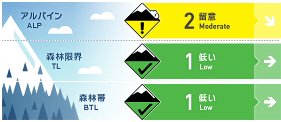
Niseko Yotei Yoichi Shiribeshi
Alpine Fair 10cm + new snow in the last 48 hours with Moderate ridge top winds with light snow transport. Natural avalanches are unlikely and human-triggered avalanches are possible. Small avalanches can happen in specific areas and large avalanches in isolated areas.
Treeline Good Natural and human-triggered avalanches are unlikely. Small avalanches in isolated areas or extreme terrain.
Below Treeline Good Low danger does not mean no danger.
信頼度:○ good □ Fair △ Low
Travel and Terrain Advice
Conditions are getting better to step out into more complex terrain this weekend. A stepping out cautiously mind set is recommended. Normal is caution advised. if the sun comes out and you see snow balls roll down slope go to less steep more shaded slopes. Cornices are larger and avoid spending time below or on top of them. Practice your avalanche rescue skills. Have a good plan, communicate with your partners and back off terrain if you have uncertainties about the conditions. (If tonight is cold and clear and you see frost (surface hoar) formed Sunday and it remains all day, report its location as if gets buried by the next snow storm it could be a weak layer for future avalanche problems.) Thank you and have a good weekend.
Avalanche Problem
ウインドスラブ Wind slab


Less new snow and wind, lack of new windslab avalanches and snow pack tests confirm the avalanche danger is dropping.
点発生湿雪雪崩 Wet Loose snow


It is unlikely, but If the sun does come out longer than forecasted and snow balls begin to roll down below your feet on very steep south facing, lower elevation slopes which are sheltered from breezes, watch out for small isolated, loose wet avalanches specially when terrain traps exist below you.
概要
Avalanche
No new significant avalanche activity reported in the last 6 days
Snowpack
Test results confirm an "upright" snow pack with out buried weak layers down in the snow pack and stronger snow as you dig deeper in the snow pack to the ground. little to no propagation reported.
Weather
High pressure and light north wind flow will bring fair weather today. Expect partly cloudy skies with sun breaks Shiribetsu and south side of Yotei, with light winds. Daytime highs expected to be below freezing and tonight lows around -15. Some light snow showers and cloudier skies possible in the Yoichi and north side of peaks. Sunday wind is light but more from the west with partly cloudy skies and possible light flurries some locations


