
Avalanche Bulletin
更新日時: 2023/01/10 07:00
Niseko Yotei Yoichi Shiribeshi
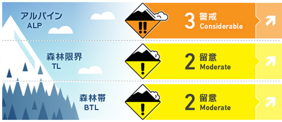
Alpine Fair More snow has fallen overnight Yoichi than Niseko area 20cm new snow @ Kiroro in the last 12 hours. With more snow and moderate winds forecasted for today and the hazard level is expected to be higher there than Niseko, Yotei and Shiribetsu. Natural avalanches are possible today and human-triggered ones are likely. Small avalanches can occur in many areas, large avalanches in specific areas, and very large avalanches in isolated areas.
Treeline Fair Natural avalanches are unlikely and human-triggered avalanches are possible. Small avalanches can happen in specific areas and large avalanches in isolated areas.
Below Treeline Fair Loose snow avalanches continue to be a problem in the steep forest zone
信頼度:○ good □ Fair △ Low
Travel and Terrain Advice
A stepping back mind set specially in the Yoichi area is a good idea today. Glide cracks are opening and getting covered. If snow rates and wind increase through out the day avalanche danger will rise. Visibility could add to the days hazard. Remember even small loose dry avalanches can sweep up into a creek, gully or into trees. As temperatures warm rapidly tomorrow and the Sun comes out, use extra caution as wet loose avalanches could become a new avalanche problem and become possible. If you see moist snow rolling down below your turns or off steep terrain. It maybe time to go to lower angle shaded slopes or higher elevations. Have a good safe day.
Avalanche Problem
ウインドスラブ Wind slab


Mountain winds follow terrain. Wind slabs can form on any aspects in complex terrain.
点発生乾雪雪崩 Dry Loose snow


Numerous rider-triggered avalanches occurred yesterday. These often failed down on 01/08 sun crust. with more snow and cold temperatures overnight and today these remain likely today.
概要
Avalanche
Nitonupuri had multiple size 1 loose dry and Soft slabs. 20-30cm low density new snow failed on the 01/08 sun crust. These slides ran fast and entraining more snow than expected. Several Wind slabs size 1 skier triggered Storm snow ran 100m long and 30m wide, no visible crown was reported. North East Yotei 15-20cm windslab skier triggered on NE aspect, around 30 degree slope. Natural triggered Glide avalanche reported Shiribetsu on 01/08. It was size 1 on a E aspect 1050m elevation. It had a 10m crown ran 150m into gully.
Snowpack
Deeper snow pack is well bonded. 20- 40cm new snow in the last 24 hours lays on 01/08 sun crust solar aspects. Wind effected scoured and transported to lee and cross loaded features snow higher elevations has created pockets of strong snow over weak.
Weather
Forecast for Niseko, Yotei, and Shiribetsu today @ 900m is for partly cloudy skies, light to moderate snow showers with light NW winds tomorrow temperatures rise with sun breaks expected. Yoichi area today @900m is forecasted moderate to have heavy snow, moderate to strong NW winds and cold temperatures -8) forecast for Wednesday forecast Partly cloudy skies moderate west winds switching to SW with temperatures warming to near -1.


