Avalanche Bulletin
更新日時: 2023/01/19 05:00
Kagura Tanigawa Hotaka
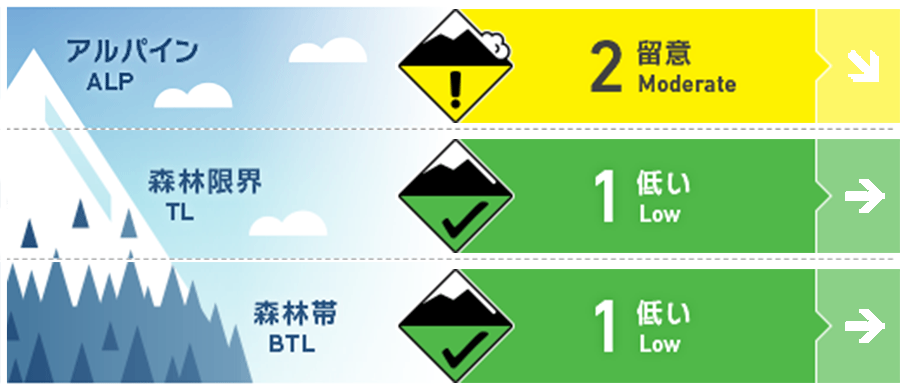
Alpine Low
Treeline Fair
Below Treeline Good
信頼度:○ good □ Fair △ Low

Travel and Terrain Advice
There has been no new snowfall, but at higher elevations, which are more susceptible to wind, wind slabs have formed on steep slopes just below the ridge and branch ridges due to snow movement caused by the strong westerly winds of the previous day. Please pay attention to the bonding. Sunny skies are forecast during the day. When snowballs begin to roll on steep slopes affected by solar radiation, it is a sign that the snowpack is losing strength. Be aware of the possibility of loose snow avalanches from large southerly steep slopes. There are exposed "terrain traps" such as deep gullies, cliffs, rocks, and standing timber that can increase damage even if the size of the generated avalanche is small.
Avalanche Problem
ウインドスラブ Wind slab


Be careful of steep slopes on the ridge and just below the branch ridge.
概要
Avalanche
No reports of new avalanches observed yesterday, but visibility was poor.
Snowpack
There is about 15-30 cm of wind-driven snowfall on top of the crust that melt-froze and refreeze on the 15th. Bonding is good, but caution should be exercised for the upcoming decrease in bonding as faceting and strong temperature gradients are being observed at the boundary. Strong westerly winds have formed wind slabs on the downwind ridge and just below the ridge. Care should be taken in bonding the boundary surfaces.
Weather
As of 5:00, the temperature at Ameda Fujiwara is -4°C. No snowfall in the past 24 hours. The Japan Meteorological Agency is forecasting clear skies and gradually becoming cloudy at night due to a high-pressure system, but subject to the influence of a trough and moist air.

