
Avalanche Bulletin
更新日時: 2023/01/19 21:00
Niseko Yotei Yoichi Shiribeshi
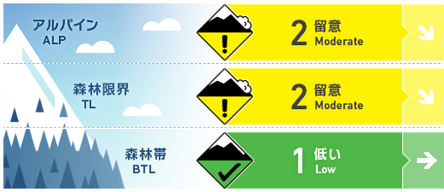
Alpine Good Windslab has formed in the alpine
Treeline Good Windslab has formed at treeline
Below Treeline Good Use normal caution
信頼度:○ good □ Fair △ Low
Travel and Terrain Advice
The storm snow overlies a hard melt freeze crust and will take time to bond. Large slab avalanches are currently unlikely however use caution on steep slopes where the storm snow is likely to release from the crust below. The rain event caused the trees to release heavy blocks of snow which are now at or just below the surface of the new snow. Travel with caution in the trees as these hidden ice bombs can be very hazardous. The next bulletin will be released Saturday morning at 7am.
Avalanche Problem
ウインドスラブ Wind slab


10-20cms of reactive windslab has formed on protected slopes.
概要
Avalanche
Size 1.5 skier accidental avalanche reported on a North aspect at 1150m in the Kiroro area on Jan. 19th
Snowpack
40-50cms of storm snow overlies a hard melt freeze crust across most of the region while the Shiribetsu area has ~20cms on the crust. The new snow requires more time to bond to the crust however in general the storm slab problem has settled out with the main concern being 10-20cms of windslab on protected slopes in the alpine and at treeline zones. A notable layer of preserved stellars down 35cms (5cms above the crust) has been observed on North aspects at treeline. It is currently unreactive however should be monitored in the days to come.
Weather
5-10cms of snow is expected overnight tonight. It will be accompanied with light winds and mild temps leading to an overcast morning Friday. A new system will push into the region Friday afternoon causing temperatures to drop, NW winds to pick up intensity and heavier snowfall Friday night.


