
Avalanche Bulletin
更新日時: 2023/01/26 07:00
Niseko Yotei Yoichi Shiribeshi
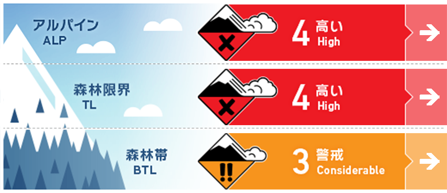
Alpine Fair Gale force winds have transported new snow onto protected lee slopes creating reactive winds slabs.
Treeline Fair Gale force winds will have transported new snow to lower elevations creating slabs on exposed lees slopes in the treeline.
Below Treeline Fair With large volumes of new snow over multiple days and turbulent winds, instabilities in the snowpack can be found at lower elevations.
信頼度:○ good □ Fair △ Low
Travel and Terrain Advice
It is not currently the time to expose yourself to avalanche terrain and an extremely cautious approach is required when traveling in the backcountry. We expect slabs to be found in multiple elevation bands therefore conservative terrain choices are required. Resort skiing or riding may be the best option if your terrain travel skills are not at a high level.
Avalanche Problem
ウインドスラブ Wind slab


Gale force winds over the previous few days have had plenty of new snow to transport and have resulted in the loading of lee slopes across easterly aspects at all elevations. Limited observations and testing suggest an instability within this latest wind-transported snow. Expect firm conditions across ridgelines and on the windward side in the alpine and pockets of slab in protected areas. At lower elevations avoid open slopes and obvious trigger points such as convex roles. Conditions suggest the avoidance of avalanche terrain until the snow has time to settle.
ストームスラブ Storm slab


With new snow up to 80cm during the most recent storm cycle storm slabs may be found on multiple aspects around specific features not effected by the wind. Testing is required of this latest new snow at all elevations and a cautious approach in all terrain is required.
概要
Avalanche
No new avalanche activity has been reported in the area however reports of shooting cracks and other signs of instability have been made from the limited observations over the last few days.
Snowpack
Up to 80cm of new snow had been recorded in the region so far during this storm cycle this has combined with gale-force winds to produce a stiff upper snowpack overlying relatively lower-density snow underneath. Lower in the pack the previously reported temperature crust can be found between 40 to 100cm down and has become weak leading to the potentiall of longer term problems. In the north of the region ,surface hoar was reportd before the storm and this may now be buried, further investigation is required to determine if it remains in the snowpack.
Weather
The deep low-pressure system that has brought the recent turbulent weather conditions will push northeast during Friday resulting in the reduction of the wind speeds. Expect continued cold temperatures and light snowfall with moderate winds from the northwest.


