
Avalanche Bulletin
更新日時: 2023/02/07 07:00
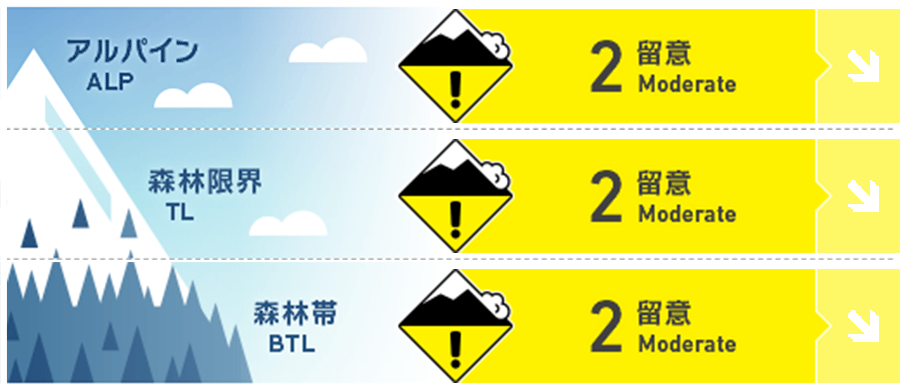
Niseko Yotei Yoichi Shiribeshi
Alpine Good
Treeline Good
Below Treeline Good
信頼度:○ good □ Fair △ Low
Travel and Terrain Advice
Better weather will offer the opportunity to get higher in the mountains over the next couple of days. Assess conditions carefully as you travel into this terrain and evaluate steep slopes carefully. Cornices have developed during the recent storms and are likely to fail with the potential to trigger a deeper, more stubborn instability. If the sun does make an appearance for any extended period of time this may cause the storm slab problem to wake up and become more reactive.
Avalanche Problem
ウインドスラブ Wind slab


Windslab has been observed on lee slopes just below ridge crest
ストームスラブ Storm slab


The storm slab is settling but may wake up on solar slopes if the sun comes out and temperatures rise.
概要
Avalanche
Size 1.5 skier accidental Storm slab failing down 30cms reported on Shiribetsu SE aspect at 12pm on Feb. 6. Size 1 unwitnessed Storm slab release reported near Kiroro on Feb. 6. Size 1 unwitnessed cornice release in Niseko Annupurri West ridge reported on Feb. 6
Snowpack
~30cms of storm snow was reactive to stability tests and skier traffic on steep slopes yesterday however is now settling and bonding. Approximately 1 to 1.5 meters of snow overlies the Jan. 18 melt freeze crust which is degrading however still present. In general the snow above the crust is well settled and rounding.
Weather
We are currently in a relatively calm period with a light NW flow continuing for the next 48 hours. Skies will be mostly overcast with the chance of the occasional sunny break, a chance of light precip at times and light West winds gusting to moderate in the alpine. Valley temps will climb to a high of -2C but temps in the mountains will remain cool.


