
Avalanche Bulletin
更新日時: 2023/02/09 07:00
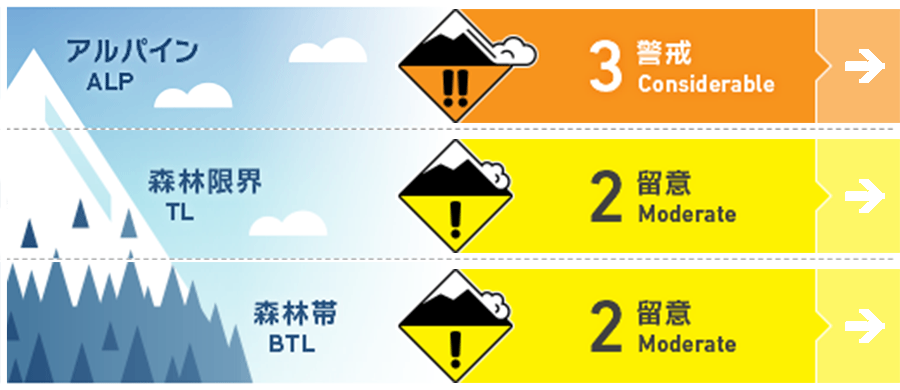
Niseko Yotei Yoichi Shiribeshi
Alpine Fair New snow and moderate to strong winds may have produced slab on lee slopes.
Treeline Fair Look for signs of fresh wind-pressed snow in exposed areas across easterly aspects.
Below Treeline Fair
信頼度:○ good □ Fair △ Low
Travel and Terrain Advice
Lower forecasted snow totals in the coming days will prompt people to venture deeper into the backcountry for fresh lines. Always be aware of who is above and below you when dropping in. Gusting winds closer to the Sea of Japan coastline may reduce visibility due to blowing snow throughout Thursday. Glide cracks remain a concern at lower elevations.
Avalanche Problem
ウインドスラブ Wind slab


Gusting northwest winds and up to 20cm of new snow may have created slab on lee easterly slopes. Testing of how the latest new snow has bonded to the previous snow surface is required.
点発生乾雪雪崩 Dry Loose snow


In steep terrain, a single person may trigger a loose dry avalanche within the latest new snow. Across solar aspects a crust has formed creating a possible bed surface for this latest new snow to run on. Watch for terrain traps below you at lower elevations.
概要
Avalanche
No new activity has been recorded since the previously reported activity on the 6th of Feb.
Snowpack
Surface hoar was reported in the north of the region previous to the latest 20cm of new snow. Periods of sunny skies have created a now buried sun on solar aspects. We continue to monitor a melt-freeze crust that remains in the mid-pack.
Weather
Up to 20cm of new snow has fallen acorss the region overnight with moderate north west winds. We are expecting reduced snow totals in the coming days. Winds will remain light to moderate from the north west before a possible southerly shift brings warmer temps into the weekend.


