
Avalanche Bulletin
更新日時: 2023/02/18 05:00
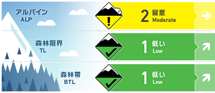
Kagura Tanigawa Hotaka
Alpine Fair
Treeline Fair
Below Treeline Good
信頼度:○ good □ Fair △ Low
Travel and Terrain Advice
Westerly winds from last night are expected to move the snow and form new wind slabs. Be careful of triggering on steep slopes on the ridge and just below the branch ridges. Sunny skies and warmer temperatures are forecast during the day. When snowballs begin to roll on steep slopes, it is a sign that the snowpack is losing strength. Be aware of the possibility of a wet loose snow avalanche from large steep slopes. Also, remember that a good slope to ski is the "avalanche terrain" itself. Remember the basics: ski one person at a time, move from safe zone to safe zone, and those in the safe zone should monitor the skiers.
Avalanche Problem
ウインドスラブ Wind slab


Be careful of steep slopes on the ridge and just below the branch ridge.
点発生湿雪雪崩 Wet Loose snow


概要
Avalanche
No reports of new avalanches observed yesterday.
Snowpack
New wind slabs are expected to form due to snow movement caused by winds that have strengthened overnight. Snowfall from past stormy weather is settling and raising bonding. Surface crusting is expected on steep southerly slopes.
Weather
As of 4:00 pm, there has been no snowfall in the past 24 hours at AMeDAS Fujiwara. The Japan Meteorological Agency (JMA) is forecasting clear skies and cloudy skies from midday, with some rain showers in the evening, due to the influence of a low pressure system and a frontal system developing over the Sea of Japan.