Avalanche Bulletin
更新日時: 2023/02/25 05:30
Hakuba
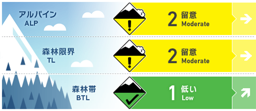
Alpine Fair
Treeline Fair
Below Treeline Fair Keep an eye on future snowfall
信頼度:○ good □ Fair △ Low

Travel and Terrain Advice
For those of you who are going to higher elevations, please be aware of the storm slabs that will be forming from the upcoming snowfall. In lower elevation areas, the high temperatures have frozen or roughened the snow surface. Keep in mind that hard and rough snow is hidden under the new snow. Along the gully, there is very hard debris from avalanches caused by previous rains. Even if you feel that the snow cover is stable, please continue to follow basic behaviors such as stopping and resting in safe areas. Proper group management based on terrain perception will reduce the damage of accidents should they occur.
Avalanche Problem
ストームスラブ Storm slab


Watch for more wind and snow in the future.
概要
Avalanche
Yesterday (February 24), a size 1 glide avalanche was observed on the southeast slope of the below treeline.
Snowpack
The snow from the previous storms has settled and there is new snow on top of it from last night. The amount of new snow is still small, about 10 cm in the northern part of the Hakuba Valley. The winter pressure pattern will continue through tomorrow, and snowfall is forecasted, so we need to watch the snowfall intensity and winds. Regarding the bonding between the Melt-Freeze crusts formed by rainfall and the overlying snow, there are reports of faceting in a few terrain pockets (where the surface snowpack is thin), but in most areas, the bonding is stabilizing.
Weather
The JMA is forecasting northerly winds, cloudy, late evening, snow, and a high of 3°C (418 m elevation) for northern Nagano Prefecture. At AMeDAS Hakuba (elevation 703 m), the temperature is -1.3°C (as of 5:00 am), with no snowfall in the past 12 hours. The Nagano District Meteorological Office is forecasting 30 cm of snowfall in the next 24 hours.


