
Avalanche Bulletin
更新日時: 2023/02/28 07:00
Niseko Yotei Yoichi Shiribeshi
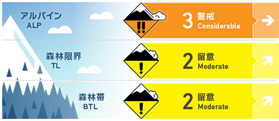
Alpine Good Strong winds over the previous few days will have created slab on lee slopes.
Treeline Good Warming temperatures during the day will create wet loose activity.
Below Treeline Good The snow surface is likely to lose cohesion in the heat of the day.
信頼度:○ good □ Fair △ Low
Travel and Terrain Advice
Two very different avalanche problems currently exist in the backcountry requiring different strategies for route planning. Watch for signs of the snow surface heating such as roller balling during the day and avoid steep terrain on solar aspects. At higher elevations pockets of wind pressed smooth slab may be seen and be reactive in single person loads. Clear trigger points such as convex rolls should not be ski'd or ridden over. Glide cracks continue to open and are a hazard alogside firm snow boulders lying on the snow surface that have released from trees.
Avalanche Problem
ウインドスラブ Wind slab


Strong to gale westerly winds could be seen transporting snow onto lee slopes on Monday at higher elevations. Expect reactive wind slab to be found on lee slopes around ridgeline and in protected areas. Look for signs of any new activity to indicate where the hazard may be found.
点発生湿雪雪崩 Wet Loose snow


Clear skies and an increasing freezing level will likely create loose wet activity. Roller balling in the heat of the day will indicate the snow surface is losing strength and moving off steep terrain would be advised.
概要
Avalanche
A wind slab was recorded on Mt Yotei on a southerly aspect at 1200m on the 27th Feb. This avalanche occurred naturally with an 80cm crown and ran for approx 300m. Numerous wet loose natural avalanches were also recorded on the 27th. In the north of the range pockets of storm slab were being triggered 0n exposed terrain on the 26th of Feb.
Snowpack
Warm temperatures and clear skies have heated the snow surface creating a sun crust on solar aspects and a possible temperature curst at lower elevations. Strong to gale winds from the west have transpoirted snow onto lee slope likey building slab at high elvations and in corss loaded terrain features.
Weather
The freezing level will climb to 1100m during the day with winds increasing to strong from the west in the afternoon on Tuesday. Expect warmer temperatures throughout the week with light to moderate winds in the coming days.


