Avalanche Bulletin
更新日時: 2024/01/05 05:30
Hakuba
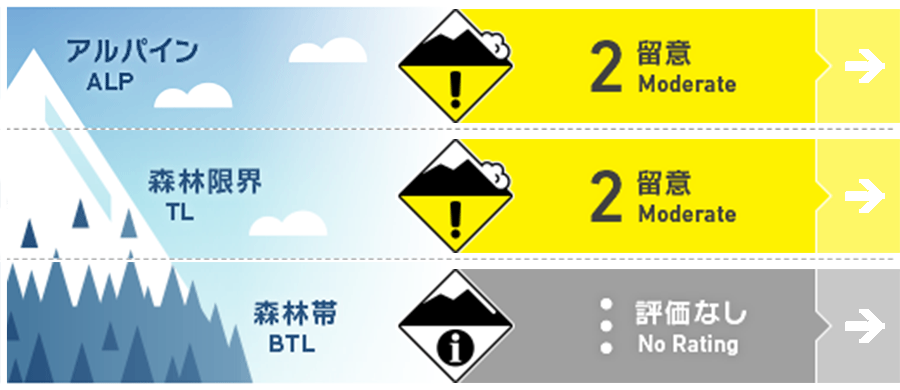
Alpine Fair
Treeline Fair
Below Treeline
信頼度:○ good □ Fair △ Low

Travel and Terrain Advice
This is a day to watch for snowpack instability in specific terrains. In higher elevations, watch for wind slabs formed by westerly to northerly winds. Be wary of slopes where the terrain is not conducive to supporting snowpack, such as convexity, etc. Even near TL (Tree Line), there is not enough snow cover yet, so watch for "terrain traps" such as trees in the terrain that could become obstacles when involved avalanche. Today is a beautiful day and will be a fun day for both climbing and skiing & snowboarding. Please continue to follow the principles of resting in a safe place and, when skiing, always wait for your companions off the avalanche terrain. Have a good day.
Avalanche Problem
ウインドスラブ Wind slab


ストームスラブ Storm slab


概要
Avalanche
Yesterday (January 4), a size 1 avalanche was reported at the morning ski resort control. The avalanche was slab avalanche on the interface between new and old snow, a locality where snow moved by northerly winds tends to accumulate. At higher elevations, visibility was poor until about noon, and no new avalanche bulletins were observed.
Snowpack
Snowfall from the night of January 3 to the morning of January 4 was about 20 cm near the TL (Tree Line). Observations of the boundary surface between new and old snowfall are limited and therefore highly uncertain. There is potential for large slab avalanches, especially since Melt-Freeze crusts are forming on the solar-exposed surfaces and the snowfall is moving with northwesterly to westerly winds. Moderate westerly winds continue to blow near the main ridge.
Weather
The Japan Meteorological Agency is forecasting a southerly wind, daytime, northerly winds, clear skies, and a maximum temperature of 10 °C (418 m elevation) for northern Nagano Prefecture. At AMeDAS Hakuba (elevation 703 m), the temperature is -4.8 °C (as of 5:00), and there has been no new snowfall in the past 12 hours.


