Avalanche Bulletin
更新日時: 2024/01/06 05:30
Hakuba
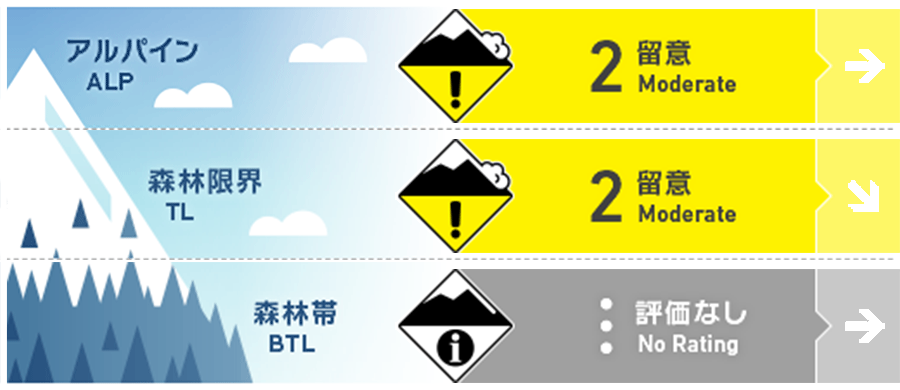
Alpine Fair
Treeline Fair
Below Treeline
信頼度:○ good □ Fair △ Low

Travel and Terrain Advice
Be aware of wind slabs that form on terrain that is not conducive to supporting snowpack, such as large convex terrain or isolated terrain with no continuity with the surrounding area. If you enter steep gully terrain in search of snow and find exposed bushes, it is a "terrain trap. At lower elevations, there are many other hazards besides avalanches, such as holes in the gully bottom. Please use a conservative route setting.
Avalanche Problem
ウインドスラブ Wind slab


Be wary of slabs formed in terrain pockets.
概要
Avalanche
Several wind slab avalanches of size 1-1.5 were observed yesterday. All were induced by skiers, some accidental, some by ski cuts. In all cases, the slabs are soft and of the soon-to-form type. In addition, loose snow avalanches caused by wet snow have been observed at lower elevations.
Snowpack
The avalanches reported yesterday were caused by new snow (about 20 cm) from the night of January 3 to the morning of January 4, which was moved by strong westerly winds and formed a windslab. Most of the slab avalanches occurred at the interface between the new snow and the old snow. Today's conditions should be considered basically the same as the previous day. In addition, moist air is moving in and the possibility of weak snowfall is in the forecast. Please consider the impact of onsite weather on snowfall.
Weather
The Japan Meteorological Agency is forecasting a southerly wind, later northerly wind, cloudy, sometimes sunny, with a high of 10 °C (418 m elevation) for northern Nagano Prefecture. At Amedas Hakuba (elevation 703 m), the temperature is -2.5 °C (as of 5:00), and there has been no new snowfall in the past 12 hours. The Nagano District Meteorological Office issued a disaster warning yesterday that heavy snowfall (70 cm) is expected from this evening through the 8th.


