Avalanche Bulletin
更新日時: 2024/01/07 05:30
Hakuba
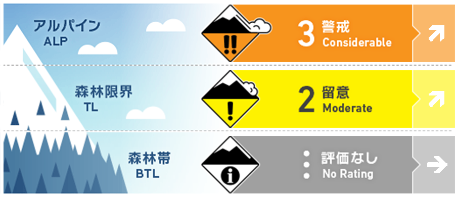
Alpine Fair Tendency to worsen as wind and snow intensify
Treeline Fair Tendency to worsen as wind and snow intensify
Below Treeline
信頼度:○ good □ Fair △ Low

Travel and Terrain Advice
Visibility is poor today, so please be on the lookout for any large start zones above you. Also, check the bonding of new and old snow up to this morning and think about whether there are any "terrain traps" below the slope you wish to ski. Since the snowpack is still shallow, it is important to consider the possibility that there are branches or cracks hidden under the new snow. The weather is obviously deteriorating, and in the event of an accident, conditions will be difficult to rescue quickly. With this in mind, please plan conservatively and give priority to safety. On the main ridge, the wind has already changed to a northwesterly, which is typical of winter conditions.
Avalanche Problem
ストームスラブ Storm slab


Watch out for increasing wind and snow
概要
Avalanche
No new avalanches were reported yesterday.
Snowpack
As of yesterday, the earlier stormy snow has settled and stabilized due to higher temperatures and solar radiation. Melt-Freeze crusts are forming on sunny slopes. In addition, since yesterday evening, there has been light rainfall at the foot of the mountain and snowfall at higher elevations, resulting in about 10 cm of new snow at around 1300 m elevation by this morning.
Weather
The Japan Meteorological Agency is forecasting northerly winds, cloudy, with occasional snow, and a maximum temperature of 4 °C (418 m elevation) for northern Nagano Prefecture. At 703 m elevation in Hakuba, the temperature is -0.8 °C (as of 5:00). No new snow has fallen at the foot of the mountain, but about 10 cm of snow has fallen in the upper part of the below treeline. The Nagano District Meteorological Observatory issued a heavy snowfall advisory at 16:26 on the 6th. According to this information, 40-60 cm of snowfall is forecast in northern Nagano Prefecture in the 24-hour period from 18:00 on the 7th to 18:00 on the 8th.


