
Avalanche Bulletin
更新日時: 2024/01/10 05:30
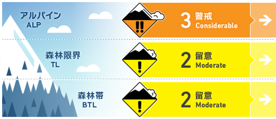
Hakuba
Alpine Fair
Treeline Fair
Below Treeline Fair
信頼度:○ good □ Fair △ Low
Travel and Terrain Advice
Pay attention to the intensity of snowfall during the day. There are Melt-Freeze crusts under the new snow that can easily become bed surfaces. Also, wind slabs are not fully stabilized, so be careful of triggering in areas where the slab thickness is thin. Even though the likelihood of triggering is low, the situation could be large avalanches. The below tree line does not yet have sufficient snow cover. Please look carefully at the terrain and set your route.
Avalanche Problem
ストームスラブ Storm slab


Snowfall is occurring under relatively light wind conditions associated with the passage of a pressure trough. Please pay attention to increased snowfall amounts.
ウインドスラブ Wind slab


Formed yesterday with strong southerly winds. Watch out for isolated terrain shapes.
概要
Avalanche
Yesterday (January 9), a size 1 loose snow avalanche was observed on the north slope of the below tree line.
Snowpack
The snow from the recent stormy weather (January 6 night to 8 noon) is settling well. New snow from this morning is on melt-freeze crusts in the south and on windslabs at higher elevations in the north. Strong southerly winds since yesterday afternoon have moved the snow violently, forming wind slabs on the east to north facing slopes.
Weather
The Japan Meteorological Agency is forecasting northerly winds, cloudy skies, snow or rain from morning to early afternoon, and daytime highs of 4 °C (418 m elevation) for northern Nagano Prefecture. At Amedas Hakuba (elevation 703 m), the temperature is -1.2 °C (as of 5:00 am). Snowfall has already begun, with about 10 cm in the upper part of the below tree line. The Nagano District Meteorological Office is forecasting 15 cm of snowfall for northern Nagano Prefecture by 6:00 a.m. on the 11th.
