Avalanche Bulletin
更新日時: 2024/01/14 06:00
Myoko
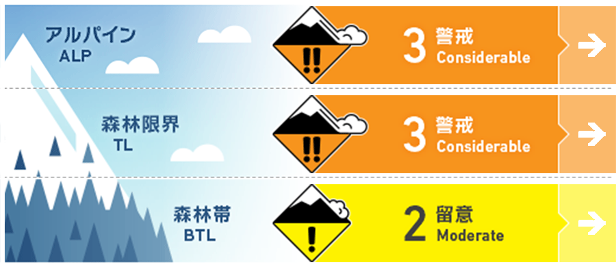
Alpine Fair
Treeline Fair
Below Treeline Fair
信頼度:○ good □ Fair △ Low

Travel and Terrain Advice
This is a day of difficult avalanche conditions. In the treeline and alpine, the snowpack has the potential for large avalanches if triggered, even though the probability of occurrence is low. Be on the lookout for areas where wind driven snow has formed slabs. Also, remember that the probability of triggering changes during the day on steep slopes exposed to solar radiation. The forest is filling in, but not enough yet. Be aware of hazardous elements hidden under fresh snow (e.g., holes in stream bottoms, lower branches of trees, etc.). Have a good day.
Avalanche Problem
ウインドスラブ Wind slab


Westerly winds are blowing in Alpine and moving the snow around. On the downwind side, especially on north to east facing slopes, there is significant avalanche potential.
ストームスラブ Storm slab


On the northern slopes, there is a relatively low-density layer under this cohesive new snow, which is structurally weak. Also, on the south slope, the new snow is on top of the Melt-Freeze crust and has significant avalanche potential.
概要
Avalanche
Yesterday (13th), a size 1.5-2 storm slab by explosives and a size 1-1.5 loose snow avalanche by ski cuts were observed at the ski resort avalanche control. No backcountry avalanche data has been received due to stormy weather and few people going into the mountains.
Snowpack
Snowfall began on the morning of the 12th and continued until the evening of the 13th. The total snowfall during the last 36 hours was 70-80 cm in the upper treeline. The westerly winds have been increasing since yesterday afternoon, moving a large amount of fresh snow to the leeward side.
Weather
The Japan Meteorological Agency is forecasting southerly winds, cloudy, sunny from early afternoon to early evening, and a daytime high of 6 °C (13 m elevation) for the Joetsu region of Niigata Prefecture. At Sasagamine, Myoko (elevation 1,310 m), the temperature is -13 °C (as of 4:45 a.m.), with 16 cm of snow having fallen in the past 12 hours and 53 cm in the past 24 hours.

