
Avalanche Bulletin
更新日時: 2024/01/20 07:00
Niseko Yotei Yoichi Shiribeshi
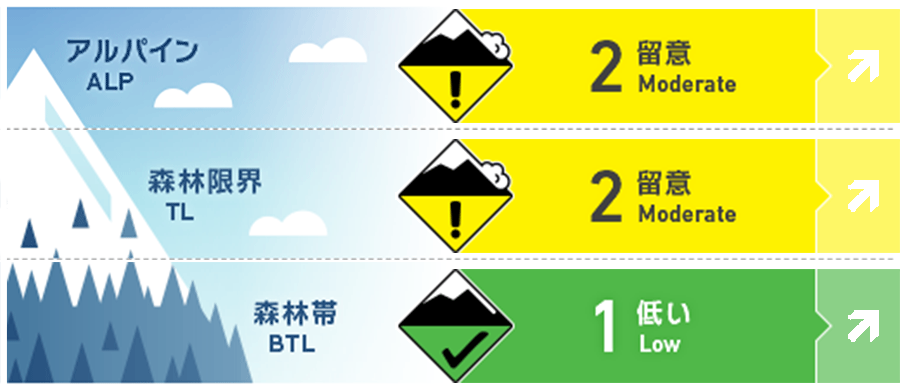
Alpine Fair The avalanche hazard will rise Monday with the start of a significant storm event.
Treeline Fair The avalanche hazard will rise Monday with the start of a significant storm event.
Below Treeline Good The avalanche hazard will rise Monday with the start of a significant storm event.
信頼度:○ good □ Fair △ Low
Travel and Terrain Advice
On Saturday and Sunday, temps will remain cool and the main concern will be monitoring the bond of the new snow and layers within the previous storm snow. As the weather changes Monday, conditions will change rapidly and the avalanche hazard will rise. The next report will be issued Tuesday morning at 7am.
Avalanche Problem
ウインドスラブ Wind slab


Wind direction is expected to change on Monday, moving the windslab problem to West and NW aspects.
ストームスラブ Storm slab





Warm temps and new snow on Monday will increase the likelihood of storm slab avalanches
点発生乾雪雪崩 Dry Loose snow




New overnight snow has fallen on a variety of old snow surfaces some of which provide and easy sliding layer.
概要
Avalanche
No new avalanches reported in the last 48 hours
Snowpack
15cms of new snow arrived overnight landing on a variety of surfaces. Prior to the new snow, solar aspects developed a melt/freeze crust up to 1000 meters yesterday while polar aspects above 1000 meters were mostly wind scoured from the Northerly winds. Pockets of soft snow remained in terrain sheltered from the wind and sun. The previous storm snow is well settled with no significant density changes.
Weather
A light Northerly flow continues through the day today; however a deep low pressure system is currently moving towards Honshu from the West. This will cause the winds in Hokkaido to shift to the East on Sunday then SE on Monday. Heavy snowfall is expected to begin Monday accompanied by mild temps and strong SE winds.


