
Avalanche Bulletin
更新日時: 2024/01/21 05:30
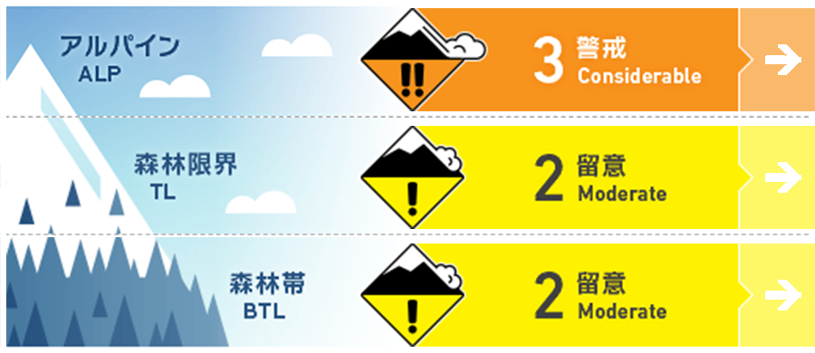
Myoko
Alpine Low
Treeline Low
Below Treeline Fair Note the degree of rainfall
信頼度:○ good □ Fair △ Low
Travel and Terrain Advice
At higher elevations, please keep an eye on fresh snow conditions up to this morning. Be alert for "terrain traps" where even small avalanches can have serious consequences. Warm southerly winds are expected to enter the area and significant temperature increases are also forecast, so please pay close attention to weather changes during the day. At higher elevations, elevated temperatures and winds may cause slabs to form quickly and instability to appear. At lower elevations, there is a risk of glide avalanche. Do not enter slopes with glide cracks and move quickly when passing under them.
Avalanche Problem
ストームスラブ Storm slab


Only in elevation zones where there was snowfall
全層雪崩 Glide slab


Note the degree of rainfall
概要
Avalanche
No new avalanche bulletin was observed yesterday (20th) due to poor visibility.
Snowpack
Near the treeline, about 15 cm of snow fell yesterday and was responsive to human stimulation. In addition, at very low elevations, expansion of glide cracks has been observed.
Weather
Today, a low pressure system with a front is expected to move east-northeast over the southern coast of Honshu. The Japan Meteorological Agency (JMA) is forecasting winds from the south, later from the west, rain, and daytime high temperatures of 10 ºC (13 m elevation) for the Joetsu region of Niigata Prefecture. At Sasagamine, Myoko (elevation 1,310 m), the temperature is 2 °C (as of 4:45 a.m.), and 3 cm of snow has fallen in the past 12 hours.