Avalanche Bulletin
更新日時: 2024/02/07 06:00
Myoko
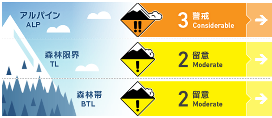
Alpine Low
Treeline Low
Below Treeline Fair
信頼度:○ good □ Fair △ Low

Travel and Terrain Advice
While winds remain relatively light at higher elevations, there are locations in the mountains where winds are converging due to terrain action and wind speeds are locally higher. Today, please pay special attention to slopes where the snow in such areas is moving and forming wind slabs. Also, when visibility is poor, situational awareness will be poor. Please maintain communication with your companions and judge conditions. The effect of solar radiation is minimal and snow sintering is progressing slowly. On very steep slopes, consider the danger of storm slab to be ongoing. Please use safe terrain wisely and use principled group management.
Avalanche Problem
ウインドスラブ Wind slab


At higher elevations, the winds are strong enough to move the dry snow and form slabs.
ストームスラブ Storm slab


概要
Avalanche
Yesterday (6th), many size 1-1.5 storm slab avalanches and loose snow avalanches were observed in the morning avalanche control at the ski resort. No reports of avalanches in the mountain area have been received due to the low number of people entering the mountain.
Snowpack
With the passage of the low pressure system, there is 30-40 cm of new snow, forming a soft slab. The bonding between this new snow and the old snow has been observed to be increasing in intensity at lower elevations, but information at higher elevations is limited, so careful checking is needed.
Weather
Today, the area is expected to be affected by a pressure trough and cold air. The Japan Meteorological Agency is forecasting winds from the south, later from the west, snow or rain, and daytime high temperatures of 5 °C (13 m elevation) for the Joetsu region of Niigata Prefecture. At Myoko Sasagamine (elevation 1,310 m), the temperature is -7 °C (as of 4:45 a.m.), with no new snowfall in the past 12 hours.

