
Avalanche Bulletin
更新日時: 2024/02/22 05:30
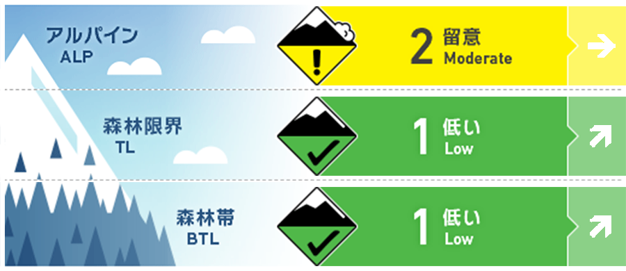
Hakuba
Alpine Low
Treeline Fair Watch for more snowfall in the future.
Below Treeline Good Watch for more snowfall in the future.
信頼度:○ good □ Fair △ Low
Travel and Terrain Advice
Pay close attention to the intensity and amount of snowfall in the coming days. Underneath the fresh snow is a hard surface that has melt-froze due to the rain, so be very alert for slips and falls. The steady rainfall has caused the snow to thaw in the lower elevations. Some tour routes that are usually accessible are not available this year. Please plan carefully. For less experienced skiers, this is a good day to enjoy the beautifully groomed runs in the ski area.
Avalanche Problem
ストームスラブ Storm slab


Currently, snowfall has just begun. Watch the intensity of snowfall in the future. On the main ridge, snow is falling with southwest to west winds of about 10 m/s.
全層雪崩 Glide slab


Still vigilant at very low elevations because of the cool nighttime temperatures.
概要
Avalanche
Yesterday (21st), a size 1 wet loose snow avalanche was observed. However, due to the rainfall, very few people entered the mountain, so information is very limited.
Snowpack
Yesterday we had positive temperatures up to the main ridge and intermittent and consistent rainfall (about 40 mm). This resulted in well-wetted snow surfaces at all elevations. Rain gullies formed on the snow surface in the alpine areas. Temperatures dropped early in the morning, so the amount of snowfall is still slight.
Weather
The Japan Meteorological Agency is forecasting northerly winds, snow or rain, cloudy nights, and daytime highs of 4 °C for northern Nagano Prefecture. At 703 m elevation in Hakuba, the temperature is -1.0 °C (as of 5:00). The Nagano District Meteorological Observatory is forecasting 15 cm of snowfall for northern Nagano Prefecture in the next 24 hours until 6:40 a.m. on the 22nd.
