
Avalanche Bulletin
更新日時: 2024/02/23 06:00
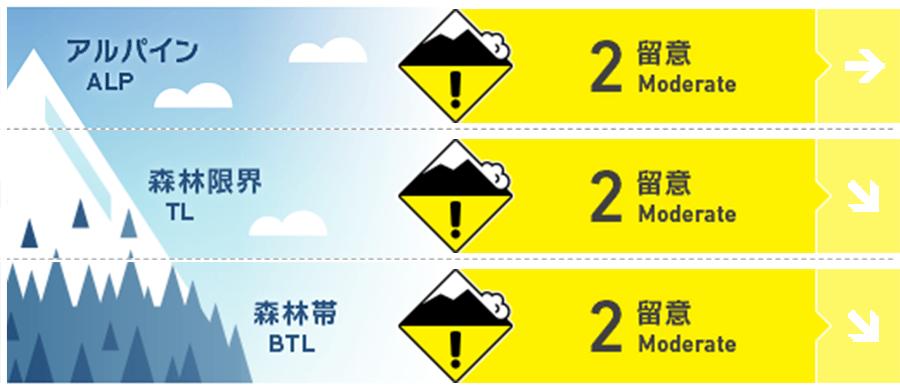
Myoko
Alpine Low Note the intensity and amount of snowfall
Treeline Low Note the intensity and amount of snowfall
Below Treeline Fair Note the intensity and amount of snowfall
信頼度:○ good □ Fair △ Low
Travel and Terrain Advice
Since the snowfall has been weak at higher elevations, watch out for storm slabs formed by the snow. Also, be wary of slipping on icy snow surfaces hidden by thin fresh snow. The heavy rains on the 21st have caused the snow to melt at lower elevations. Some tour routes that are usually accessible may not be available this year. Please plan carefully.
Avalanche Problem
ストームスラブ Storm slab


Snowfall since yesterday has formed storm slabs. Moderate winds from the southwest to west are blowing in Alpine.
概要
Avalanche
No new avalanches were reported yesterday (22nd).
Snowpack
New snow (15-20 cm) is on the snow surface that has been wetted by rainfall and subsequently frozen hard. Limited observations indicate that bonding of the new snow with the Melt-Freeze crust is not bad, but continued observation is needed as a hard snow surface makes for a good bed surface. It has been reported that the glide crack movement is subsiding, partly due to cooler temperatures.
Weather
The Japan Meteorological Agency is forecasting winds from the south, then from the north, snow or rain, cloudy before noon, and a daytime high of 4 °C (13 m elevation) for the Joetsu region of Niigata Prefecture. At Sasagamine, Myoko (elevation 1,310 m), the temperature is -7 °C (as of 4:45 a.m.) and 13 cm of snow has fallen in the past 24 hours.