
Avalanche Bulletin
更新日時: 2024/03/20 06:00
Myoko
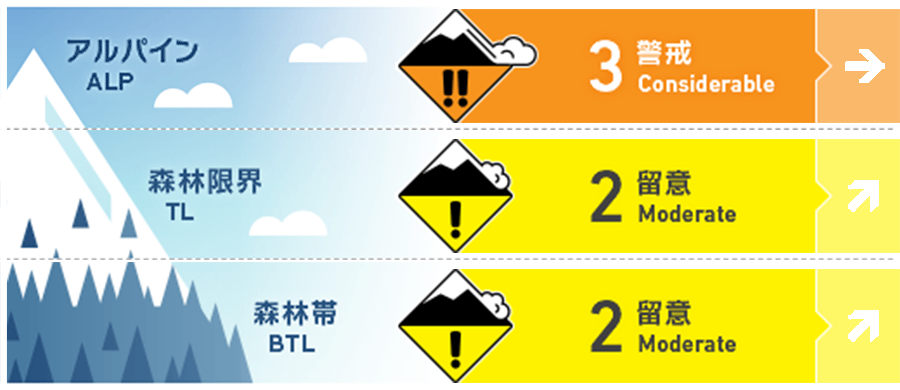
Alpine Low
Treeline Low
Below Treeline Fair
信頼度:○ good □ Fair △ Low
Travel and Terrain Advice
At this time, there is not yet a significant amount of snowfall, but the weather station has indicated that a heavy snow warning may be issued in the future. Please be aware of the strengthening of wind and snow in the coming days. Whatever type of avalanche is present, there are safe places in the mountains that are resistant to avalanches. Please observe the terrain carefully and try to minimize the time and number of people entering avalanche terrain. And when you take a break, be sure to stay out of the avalanche terrain. Group management based on terrain awareness will prevent major avalanche accidents. Plan tours with weather conditions in mind. Inexperienced groups are recommended to ski within the ski area.
Avalanche Problem
ストームスラブ Storm slab


This snowfall is due to weak southwest winds associated with the passage of a low pressure system. Not a lot of snowfall so far this morning, but caution is advised where there is a slab tendency.
全層雪崩 Glide slab


Watch out for glide avalanches at very low elevations, where it is raining. Stay away from slopes that already have glide cracks.
持続型スラブ Persistent slab


A persistent weak layer has formed in the middle layer of snow cover and has a high degree of uncertainty.
概要
Avalanche
No new avalanches were reported yesterday (19th).
Snowpack
Where the wind has a strong influence, the hard Melt-Freeze layer or the wind-scoured snow surface is covered with snow that has fallen since last night. In areas where the wind has less influence, new snow is on the settling snow surface. In any case, it is necessary to check the bonding between the new snow and the old snow. In places with low elevation and precipitation, the nighttime cold is also weak, so beware of glide avalanches.
Weather
Today, a low pressure system is expected to pass over the Hokuriku region and move to the east of Japan, resulting in a high pressure system in the west and low pressure system in the east. The Japan Meteorological Agency is forecasting southerly winds, then slightly northwesterly winds, snow or rain, and daytime high temperatures of 9 °C (13 m above sea level) for the Joetsu area of Niigata Prefecture. At Sasagamine, Myoko (elevation 1,310 m), the temperature is -3 °C (as of 4:45 a.m.) and 4 cm of snow has fallen in the past 12 hours.