Avalanche Bulletin
更新日時: 2024/03/21 06:00
Myoko
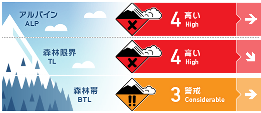
Alpine Low
Treeline Low
Below Treeline Fair
信頼度:○ good □ Fair △ Low

Travel and Terrain Advice
These are dangerous avalanche conditions. Even if you are at a lower elevation, carefully consider whether there is a large start zone above you. Deep fresh snow also makes travel difficult and makes it hard to move quickly through the danger zone. Instead of taking your usual route, a safer, more conservative route setting is needed. For less experienced groups, this is a good day to enjoy the fresh snow in the ski area. When doing so, please observe the areas where you are allowed to ski. This is crucial for your safety as well as the safety of other guests.
Avalanche Problem
ストームスラブ Storm slab


It is snowing heavily with northwesterly winds.
持続型スラブ Persistent slab


A persistent weak layer is buried in the middle layer of snow cover. Massive snowfall can add significant load to the snowpack.
概要
Avalanche
Yesterday (20th), the weather was poor and no avalanches were reported in the mountain areas.
Snowpack
There was not much snowfall associated with the passage of the low pressure system until the morning of the 20th. Since then, the pressure has changed to a winter pressure pattern and temperatures have dropped significantly, resulting in a significant amount of snowfall. This new snow is on the Melt-Freeze crust in all directions at lower elevations and to the south or windward at higher elevations. Today, all of the new snow could slab avalanche from this boundary, or from weak layers within the new snow.
Weather
The Japan Meteorological Agency is forecasting winds out of the west, with a slight wind chill, snow and daytime high temperatures of 6 °C (13 m elevation) for the Joetsu region of Niigata Prefecture. At Sasagamine, Myoko (elevation 1,310 m), the temperature is -10 °C (as of 4:45 a.m.), with 34 cm of snow having fallen in the past 12 hours and 65 cm in the past 24 hours.

