Avalanche Bulletin
更新日時: 2024/03/21 06:00
Niseko Yotei Yoichi Shiribeshi
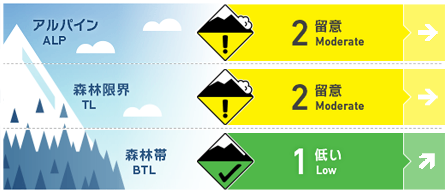
Alpine Good
Treeline Good
Below Treeline Good The snow surface will lose cohesion as temperatures and sunshine increase.
信頼度:○ good □ Fair △ Low
Travel and Terrain Advice
With the snow pack settling combined with low winds and periods of sunshine spring conditions are slowly taking hold. Great turns can still be found across the backcountry although pockets of slab can still be found in protected areas at upper elevations. By the weekend the sun and air temperature will become the dominant factor and wet loose activity will increase.
Avalanche Problem
ウインドスラブ Wind slab


Wind slab formed earlier in the week has begun to settle and gain strength. Isolated pockets in protected areas may still be reactive to heavy loads however little reactivity has been observed in the past 24 hours. Be wary of natural trigger points in the alpine such as convex roles on slopes lee to the north west winds.
点発生湿雪雪崩 Wet Loose snow





In the coming days the air temperatures are expected to rise above freezing at lower elevations. These higher temperatures will increase the possibility of wet loose activity on all aspects below treeline. Steep sided terrain traps such as creek beds increase the possibility of a deep burial even in a small slow moving wet point release.
概要
Avalanche
No new activity has been reported.
Snowpack
The storm event from earlier in the week appears to have bonded to the previous snow surface. Northerly aspects remain firm and wind stripped at higher elevations. At lower elevations the upper snow pack has been temperature effected and is becoming heavy in the middle part of the day.
Weather
A high-pressure system is approaching Hokkaido with expected settled weather for the later part of the week. Low northerly winds will be in effect before a southerly change at the weekend bringing warmer temperatures and broken sunshine. We expect the freezing levels to rise above 500m in the coming days.

