
Avalanche Bulletin
更新日時: 2021/02/23 05:00
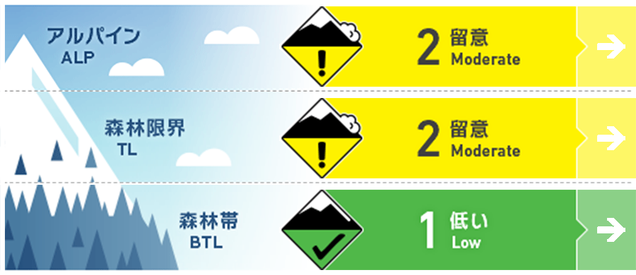
Hakuba
Alpine Fair
Treeline Fair
Below Treeline Fair
信頼度:○ good □ Fair △ Low
Travel and Terrain Advice
At high altitude from the upper part of the forest zone, pay attention to storm slabs that formed in snowfall from last night. The merging state of new and old snow is currently uninformed and has a high degree of uncertainty. It should also be noted that locally unstable snow is deposited, since it is accompanied by a strong western wind. Even though the snow surface is seemingly beautiful with fresh snow, remember that the snow surface was rough due to the temperature up to yesterday, and it is hard and frozen and hidden.
Avalanche Problem
ストームスラブ Storm slab


昨晩からの降雪によるスラブ
概要
Avalanche
Yesterday (February 22) snowball was observed at lower elevations than the upper forest belt, regardless of slope orientation. In addition, wet snow point avalanches were taking place on the steep slope where the sun was strongly bathed. Near the main ridge of the Alpine, an avalanche of size 2 windslab has been observed due to strong southerly winds.
Snowpack
From late night last night until this morning, it has been a 10-15cm snowfall at the top of the forest belt. Temperatures are starting to decline since the unknown, and snowfall is accompanied by strong western winds.
Weather
Japan Meteorological Agency predicts northern Nagano Prefecture's wind, hag, and a maximum temperature of 6°C (418m altitude). The temperature is 1.9 ℃ (as of 4:00) on AMeDAS Hakuba (elevation 1310m).
