
Avalanche Bulletin
更新日時: 2021/12/14 07:00
Niseko Yotei Yoichi Shiribeshi
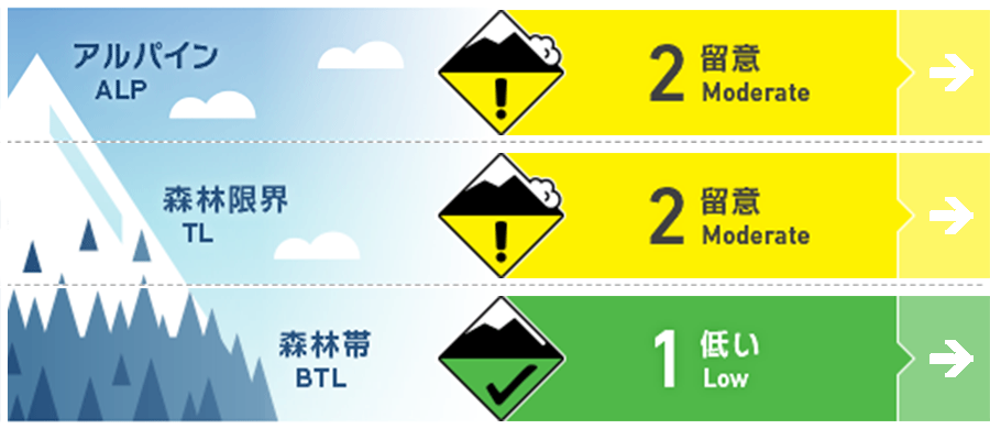
Alpine Fair 温かい天候が続いた後、荒天によるまとまった雪と強風が吹き荒れました。新雪は旧雪と十分に結合するまで不安定な状態となります。The storm brought a brief period of heavy snow and strong winds to the region after an extended period of warm stable weather. The new snow will be reactive in the alpine until it bonds to the lower pack.
Treeline Good ウインドスラブが稜線下の強風から保護された場所に形成しています。Windslab has formed on protected features and just below ridge crest.
Below Treeline Good 樹林帯の積雪はまだ少なく、よく焼結し、安定しています。ここに荒天の雪が載っていますが、降り始めの気温が高めだったこともあり、結合は良い状態にあります。The snowpack below treeline remains thin and well anchored. New snow has bonded well due to warm, wet weather at the onset of the storm.
信頼度:○ good □ Fair △ Low
Travel and Terrain Advice
At high altitudes, the combination of fresh and old snow is still not enough, so be especially careful on the slopes where snow is deposited under the influence of the wind. The next avalanche information is scheduled for 7:00 on Thursday. This winter, we are aiming for announcements on Tuesdays, Thursdays, and Saturdays. Use extra caution on windloaded slopes particularly at higher elevations where the new snow is less well bonded to the old snow surface. The next bulletin will be released at 7am Thursday morning. Bulletins are available Tuesday, Thursday and Saturday throughout the winter. Early season conditions continue at all elevations and many hazards are lurking just below the new snow surface. Access and egress from the backcountry remains challenging due to the lack of snow.
Avalanche Problem
ウインドスラブ Wind slab


アルパインエリアでは、極めて強い風によって積雪は激しい削剥を受けており、むしろ、標高がやや下がる場所でウインドスラブが発達しています。Strong to gale force alpine winds have scoured the alpine pushing the storm snow down the mountain. This has created windslab on protected features particularly at treeline.
概要
Avalanche
No new avalanches have been reported in the last 48 hours, but it must be taken into account that due to stormy weather, visibility was very poor. In general, during stormy weather, it should be considered that on the slopes where snow accumulates under the influence of the wind, there was a naturally occurring avalanche cycle. No new avalanches have been reported in the past 48 hours however visibility has been very limited due to heavy snow and strong winds. It is likely that a natural avalanche cycle occurred on steep wind loaded slopes during The storm.
Snowpack
There was a snowfall of 20-30 cm in the past 48 hours, and it was on top of a stable snow cover. The stormy weather this time started with a high temperature, so it is particularly well coupled at low elevations. 20-30cms of new snow has fallen over the past 48 hours settling on a well consolidated BASE. The Storm started warm and wet creating strong initial bonds particularly at lower elevations.
Weather
Today and tomorrow will be mild, and the freezing altitude will rise to an altitude of 450m, but tomorrow (Wednesday) night, it is forecast to decline again. In addition, there will be moderate westerly winds for the next 48 hours, and some rainfall is forecast on Tuesday night. Mild temperatures today and tomorrow will cause the freezing level to climb to 450m before dropping again tomorrow (Wednesday) night. Moderate West winds will persist for the next 48 hours with some light precipitation expected Tuesday night.


