
Avalanche Bulletin
更新日時: 2023/01/31 05:30
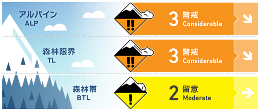
Hakuba
Alpine Fair Be on the lookout for wind slab formation.
Treeline Fair Be on the lookout for wind slab formation.
Below Treeline Fair
信頼度:○ good □ Fair △ Low
Travel and Terrain Advice
Great weather but a difficult day for mountain conditions. There is heavy snowfall and it is being moved by strong winds. In the upper snowpack there is the danger of wind slabs and storm slabs. This is an instability that any avid backcountry skier has surely experienced many times. As always, be on the lookout for slab formations and look for skiing lines where the terrain supports the snowpack. Starting the day with smaller terrain is also a good idea. On the other hand, there is a nasty weak layer in the middle of the snowpack that forms persistent slabs. This type of avalanche is less likely to be triggered, but once triggered, it can be large in magnitude. Triggering will be where the weak layer is shallowly buried. Even if the snow surface layer is hard due to wind, it will trigger if the weak layer is located shallowly. Therefore, please choose your terrain more carefully and take a larger safety margin than usual. Powder skiing goes hand in hand with the history of mountaineering. Hakuba is a land of long mountaineering history and culture. The avalanche bulletin is provided to support everyone who skis in the mountains. Have a nice day.
Avalanche Problem
ウインドスラブ Wind slab


Be wary of isolated terrain where the wind blows around the branch ridge and the snow is cross loading.
ストームスラブ Storm slab


持続型スラブ Persistent slab


Multiple observations, including a step-down fracture line with a depth of 2 m and a loud noise at the onset (generated by the tensile failure of a thick slab), indicate that the avalanche that occurred on January 29 on the east slope of Tenguhara was most likely a size 2.5 or larger persistent slab. An outline is currently under investigation.
概要
Avalanche
No new avalanches were reported yesterday (January 30), partly due to poor visibility. There are reports of whumpfing sounds Below Treeline.
Snowpack
Snowfall intensified yesterday afternoon (January 30), and by evening there was 30-50 cm of new snow around Below Treeline. This brings the total new snowfall since the afternoon of January 29 to about 50-80 cm. This new snow was influenced by strong north-west winds at higher elevations. Despite limited observations, instability caused by the combination of Melt-Freeze crusts formed by the January 14 rainfall and faceted snow is still a concern. It has been observed that the temperature gradient is becoming smaller. However, the relatively shallow burial of this weak layer is causing results that should be noted in the test results.
Weather
The Japan Meteorological Agency is forecasting southerly winds, northerly winds during the day, cloudy, sunny from midday, snowy in places until morning, and a maximum temperature of 1°C (418m elevation) for northern Nagano Prefecture. At the valley of Hakuba (elevation 703m), the temperature is -6.6°C (as of 5 am), and 1 cm of snow has fallen in the past 12 hours.
