
Avalanche Bulletin
更新日時: 2024/03/04 05:30
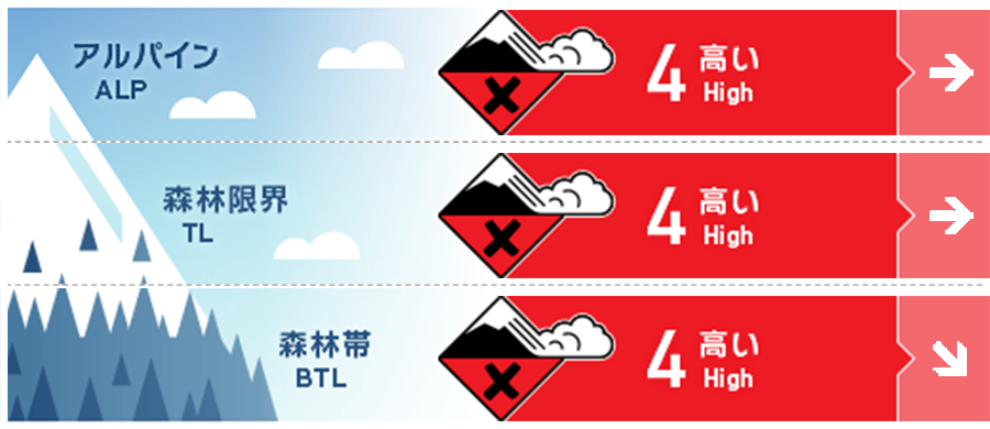
Hakuba
Alpine Low
Treeline Low
Below Treeline Fair
信頼度:○ good □ Fair △ Low
Travel and Terrain Advice
Very dangerous avalanche conditions. Very large avalanche conditions are possible on the north to east slopes. Even if you are at lower elevations, you need to be aware of large start zones at higher elevations. Even if you are in the forest, the avalanche start zones and tracks within them need to be well identified, with careful terrain selection and conservative decision-making. For less experienced groups, this is a suitable day to enjoy fresh snow in the ski area. When doing so, please observe the trails that can be skied. It is for your safety and, at the same time, crucial to the safety of other guests.
Avalanche Problem
ストームスラブ Storm slab


From yesterday afternoon to this morning, there has been about 30 cm of snowfall below treeline. Westerly winds averaging 10 m/s are blowing on the main ridge.
持続型スラブ Persistent slab


There is evidence of faceting snow that could be problematic not only at higher elevations, but also in the upper part of the below treeline (around 1,700 m). The new snow since yesterday has added significant load to the persistent weak layer. In general, persistent slabs are known to be activated by avalanche activity in the event of a major weather event (such as today's heavy snowfall).
概要
Avalanche
Yesterday (3rd), a size 1.5 wind slab avalanche was reported. It was triggered by a skier. Shooting cracks were also reported. In addition, several size 1.5-2 slab avalanches were observed that appeared to have occurred within the past 24 hours.
Snowpack
Snowpack conditions are extremely complex, with variability by location. The middle layer of snowpack facing north to east has a combination of Melt-Freeze crust (formed by rainfall on February 21) and faceted snow that can occur large avalanches. Avalanches caused by this weak layer have also been observed. The upper snowpack still contains snow with large grain size that fell during the passage of a low pressure system (February 29), and some of it is faceting, causing avalanches to occur. The snow surface varies from exposed hard snow surfaces, wind crusts forming, or soft areas due to the previous strong winds. Here you can see the snowfall since yesterday afternoon.
Weather
The Japan Meteorological Agency is forecasting northerly winds, snow, cloudy after noon, then sunny, with a daytime high of 8 ºC for northern Nagano Prefecture. At 703 m elevation (Hakuba), the temperature is -2.2 °C (as of 5:00 a.m.), and 17 cm of snow has fallen in the past 12 hours.
