
Avalanche Bulletin
更新日時: 2024/03/20 05:30
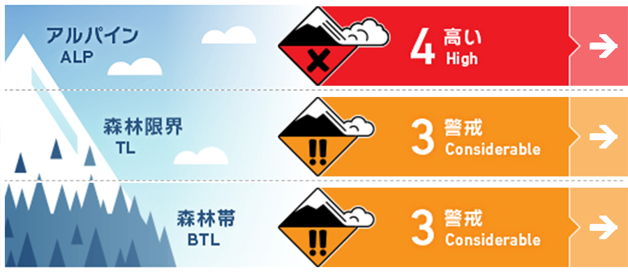
Hakuba
Alpine Low
Treeline Low Watch for wind and snowfall in the coming days.
Below Treeline Fair Watch for wind and snowfall in the coming days.
信頼度:○ good □ Fair △ Low
Travel and Terrain Advice
Dangerous avalanche conditions. This is a day for careful route selection and conservative decision-making. Whatever type of avalanche is present, there are safe places on the mountain that are safe from avalanches. Observe the terrain carefully and try to reduce the time and number of people entering avalanche terrain. And when you take a break, be sure to stay out of the avalanche terrain. Group management based on terrain awareness will prevent major avalanche accidents. For inexperienced groups, powder riding in the ski area is a fun day. When doing so, please be sure to observe the areas where you are allowed to ski. It is for your safety and at the same time crucial for the safety of other guests.
Avalanche Problem
ストームスラブ Storm slab


There has been 20-30 cm of snowfall since last night at around 1,500 m elevation. This snowfall is due to weak southwest winds associated with the passage of a low pressure system. The more slab trending areas have a higher chance of triggering.
点発生乾雪雪崩 Dry Loose snow


Snow continues to fall on the main ridge with weak winds averaging less than 10 m/s. On very steep slopes where snow tends to accumulate, one should be alert for loose snow avalanches, even if one is in the forest.
持続型スラブ Persistent slab


A persistent weak layer has formed in the middle layer of snow cover and has a high degree of uncertainty.
概要
Avalanche
No new avalanches were reported yesterday (19th).
Snowpack
Where the wind has a strong influence, the hard Melt-Freeze layer or the wind-scoured snow surface is covered with snow that has fallen since last night. In areas where the wind has less influence, new snow is on the settled snow surface. In any case, it is necessary to check the bonding between the new snow and the old snow. It is a bad sign if the old snow surface is smooth and hard, and if the upper layer of new snow also has enough slab characteristics. Choose terrain with a large safety margin. North of the treeline and below treeline, it has been observed that there are areas where snow with weak bonding has formed on the Melt-Freeze crust that has formed due to the high temperatures since the beginning of March. This new snow is putting a load on those areas, which is a dangerous sign.
Weather
Today, a low-pressure system is expected to pass over eastern Japan and move eastward. The Japan Meteorological Agency is forecasting southerly winds, then northerly winds, snow, sometimes cloudy, and daytime high temperatures of 7 °C for northern Nagano Prefecture. At 703 m elevation in Hakuba, the temperature is -0.2 °C (as of 5:00 a.m.). The Nagano District Meteorological Observatory forecast 60 cm of snowfall for northern Nagano Prefecture at 4:38 a.m. on March 20 in the 24-hour period ending at 6:00 a.m. on March 21.
