
Avalanche Bulletin
更新日時: 2024/03/21 05:30
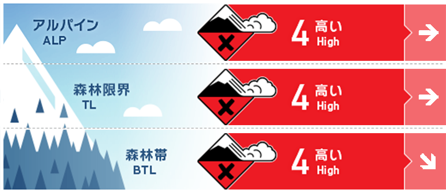
Hakuba
Alpine Fair
Treeline Fair
Below Treeline Fair
信頼度:○ good □ Fair △ Low
Travel and Terrain Advice
Very dangerous avalanche conditions. Even if the weather improves in the coming days, the instability will not be resolved immediately. Please do not let your guard down. Size 3 avalanche conditions are possible on the large open slopes on the south side of Goryu Toomi-one and Happo-one. This would be an avalanche large enough to reach from the top of the ski area to the river at the bottom of the valley. This is a good day for inexperienced groups to enjoy fresh snow in the ski area. If you do so, please observe the ski area. This is crucial for your safety as well as the safety of other guests.
Avalanche Problem
ストームスラブ Storm slab


Conditions are such that avalanches of large magnitude can easily occur. Even at lower elevations, it is necessary to think carefully about whether a large start zone exists above you. With northwest to north winds averaging over 15 m/s, large avalanches can occur on the southern slopes, even at low elevations.
点発生乾雪雪崩 Dry Loose snow


On a very steep slope, unaffected by wind.
持続型スラブ Persistent slab


A persistent weak layer is buried in the middle layer of snow cover. Massive snowfall can add significant load to the snowpack.
概要
Avalanche
Yesterday (20th), a number of avalanches of size 1-1.5 were reported at the morning safety control at the ski resort. These were caused by snow that fell since the evening of the 19th, at the boundary of the old snow and the slab avalanche. As for the mountain areas, no reports have been received due to bad weather conditions.
Snowpack
Following the snowfall associated with the passage of a low-pressure system (evening of the 19th to noon of the 20th), the pressure changed to a winter type since yesterday afternoon, and the temperature has dropped significantly. The snowfall amount this time exceeded 70 cm in the northern part of the Hakuba Valley. This new snow is on the Melt-Freeze crust in all directions at lower elevations, and to the south or windward at higher elevations. Today, all of the new snow will slab avalanche from this boundary surface or from weak layers within the new snow. The overall structure of the snowpack also has an unstable "upside-down structure" with high-density snow on top of relatively low-density snow. It is more important to understand the big picture than to observe snowpack data at a single location.
Weather
The Japan Meteorological Agency is forecasting northerly winds, cloudy, with occasional snow, and a daytime high of 3 °C for northern Nagano Prefecture. At 703 m elevation Hakuba, the temperature is -5.3 °C (as of 5:00 a.m.), and 16 cm of snow has fallen in the past 12 hours. The Nagano District Meteorological Observatory forecast 30 cm of snowfall for northern Nagano Prefecture at 4:15 a.m. on March 21 in the 24-hour period ending at 6:00 a.m. on March 22.
